The Snohomish is formed by the Skykomish and Snoqualmie river combining, and is the namesake of the entire system.
In this post I’ll cover access locations you can use to fish from, or in some cases launch a boat.
The Snohomish is tidally affected for much of its length. The tidal portion ends around Bob Heriaman park. Be aware of tides when planning your trip, especially launching and retrieving your boat.
Boats with props are generally fine to use up to the town of Snohomish. However be careful as there are log embedded in a few locations, as well as debris at times. Higher than the Snohomish a jet sled is highly recommended.
For tips, tricks and techniques on how to catch the various species check out these resources:
As always use this information as a starting place for your fishing adventures. Other access locations exist for you to find in your explorations. Be respectful of private property, and clean up after yourself.
Be safe when using these access locations and do so at your own risk.

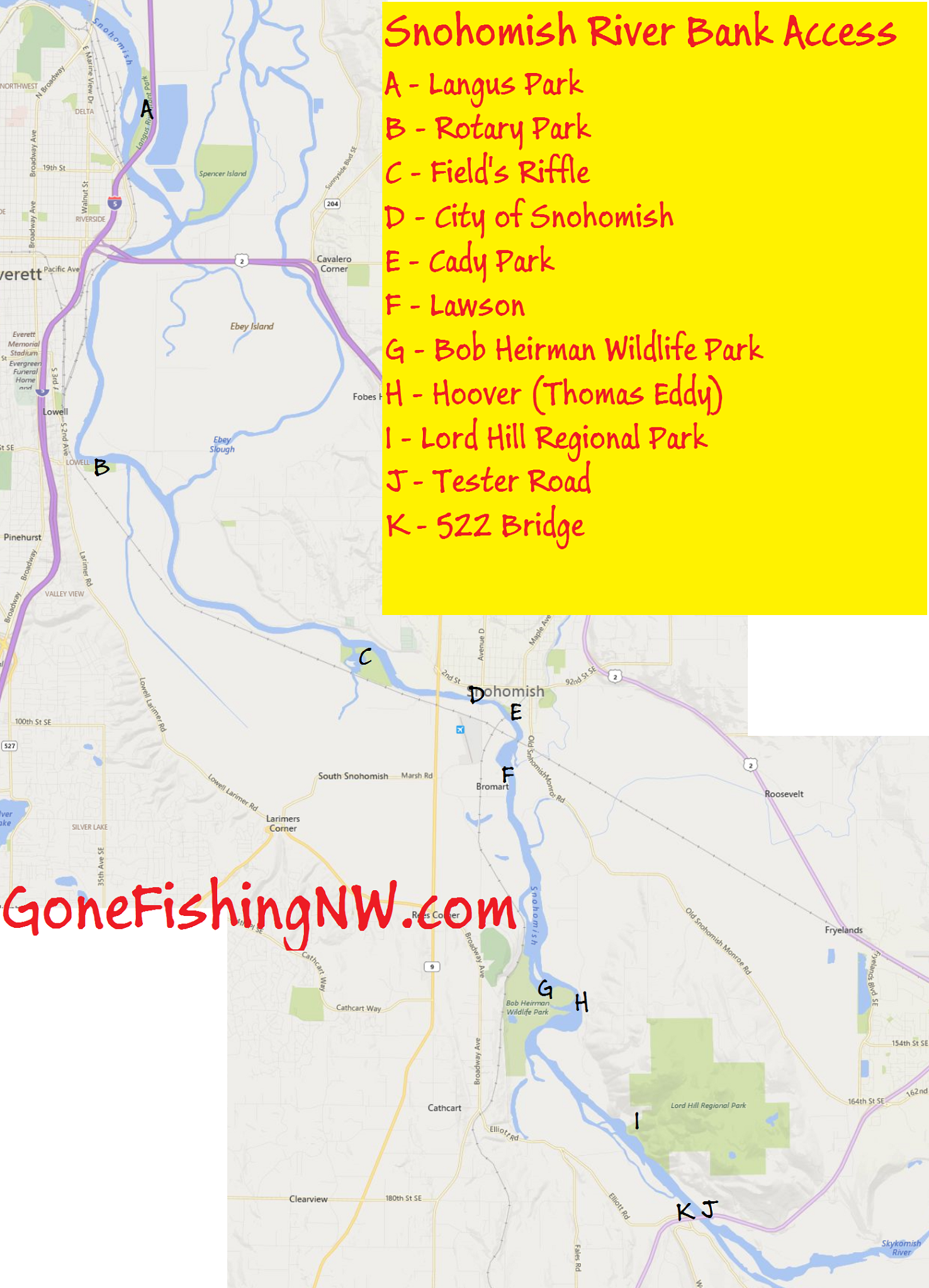
A) Langus Park
This park is owned by the City of Everett. It contains a boat launch, as well some piers with fishing access.
B) Rotary Park
This is another park owned by the City of Everett. It has a boat launch, and a few places one can access the river – especially at low tide.
C) Fields Riffle
This is a nature park which has access to a large sand bar.
D) City of Snohomish
Around there are numerous small spots to access the river at the City of Snohomish.
E) Cady Park
Cady Park is a city of Snohomish park with a boat launch. Parking is quite limited.
F) Lawson
This is a WDFW access area.
G) Bob Heirman Wildlife Park
This is a Snohomish county nature park. It has trails which lead down to the river.
H) Hoover (Thomas Eddy)
This is a WDFW access point across the river from Bob Heirman.
I) Lord Hill Regional Park
This is a Snohomish country park with trails one can follow down to the river.
J) Tester Road
This is an unofficial access area. Parking is limited to the side of the road. Several trails exist down to gravel bars near the 522 bridge.
K) 522 Bridge
This is an unofficial access point. Very limited parking. Fishing spots are right under the 522 bridge, and a narrow path that runs along the river.
I drove out to Snohomish today and found no indication that Fields Riffle exists. my GPS showed me right in front of it. There were no signs and a steel gate with a chain and padlock. I ask several people in Snohomish and they told me they never heard of it. If I missed something Please let me know. I was really looking forward to fishing there
Sorry you had trouble finding it. Its been a few years since I’ve been there, so things might have changed. Snohomish Country’s website still lists it. The picture on their site shows where the access is from the road. https://snohomishcountywa.gov/Facilities/Facility/Details/Fields-Riffle-182
Hope that helps
One last thought – In these times of Covid it is possible that it isn’t following normal opening hours. Suggest contacting Snohomish County Parks to determine if it is currently open.
Hello, looking to fish at Lowell Snohomish River park from the shore. What should I be fishing for right now during late June/early July?